1) View of Bertozzi Wildlife Management Area entrance from rail bed. The engineering study will consider this as a possible parking area. (Back to map)
2) Entrance to Bertozzi Wildlife Management Area from Townsend Road in Groton. (Back to map)
3) The rail bed at the southern crossing of Crosswinds Drive in Groton. The engineering study will consider the use of various techniques at places such as this one to discourage nuisance parking, such as signs describing legitimate parking areas . (Back to map)
4) The view near Crosswinds in Groton. (Back to map)
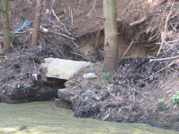
5) Failing culvert behind Harbor Village Shopping Center (north side). The engineering study will assess the status of all culverts along the rail trail. This particular culvert was identified as an important issue during a preliminary reconnaissance by the engineering firm of Faye, Spofford, and Thorndike. (Back to map)
6) The Squannacook River as seen about 100 yards east of South Road in Townsend. (Back to map)
7) Informal parking area east of Shepherd's on south side of Route 119. A parking area on MBTA land here will be evaluated as part of the engineering study. Route 119 is to the left, and the Squannacook River is to the right. (Back to map)
8) The MBTA-owned rail bed passing in front of Shepherds in Townsend. The engineering study will address any possible impact on business operations. (Back to map)
9) Harbor Pond in Townsend in the fall. (Back to map)
10) A view facing east of the rail bed crossing South Street. The engineering study will consider a number of possible options in the South Street/Harbor Pond area. (Back to map)
11) The rail bed passing between the Townsend Historical Society's Reed Homestead and Harbor Pond. Input from the Townsend Historical Society will be requested as part of the engineering study. (Back to map)
12) Fall view of Harbor Pond from behind the Reed Homestead. (Back to map)
13) Misty view of the rail bed between Harbor Pond and the Townsend Historical Society's Harbor Church. (Back to map)
14-15) Rail bed covered by Harbor Auto fence in Townsend, as seen from west side. Possible solutions to this issue will be addressed by the engineering study. (Back to map)
16) Two residences on Main Street in Townsend close to the rail bed. The engineering study will include a preliminary needs assessment of screening and/or barriers to mitigate trail impact on abutting residences.
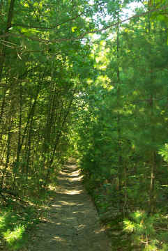
17) The rail bed east of Old Meetinghouse Road in Townsend. (Back to map)
18) The rail bed west of Old Meetinghouse Road in Townsend. (Back to map)
19) Captain the Brittany Spaniel walking the rail bed approximately 1/4 mile east of Sterilite. Here the rail bed is cut through higher ground, so water can collect on the sides of the trail during wet periods. This picture was taken May 29, 2006, the day after severe flooding in southern New Hampshire. The engineering study will request input from the Groton and Townsend Conservation Commissions while addressing the issues of drainage and wetlands along the trail. (Back to map)
20) The rail bed near Depot Street in Townsend Center. The possibility of erosion along the steep grade south of the rail bed will be addressed by the engineering study. (Back to map)
21) The proposed trail terminus on Depot Street in Townsend center. This is one of a number of possible parking areas in Townsend center to be considered by the engineering study. (Back to map)